The purpose of the ICI inversion system is to reconstitute the vertical
structure of the atmosphere in terms of temperature and moisture by inverting
the radiative transfer equation. This is done using observations from the
sounders, each measured radiative energies originating from a different
atmospheric region for each channel.
The aim of the ICI inversion package is to process the observations collected by an HRPT local station for the NOAA orbiting satellites. It is therefore located downstream in relation to the HRPT data pre-processing software and is interfaced with the output files of the AAPP package.
The ICI package system is meant to be operational in spite of the constraints involved: software environment control, durable product quality, quick response to a change of satellite...
The first aim of the ICI line of products was to supply inverted products to Météo-France for nowcasters help and for the monitoring of Météo-France numerical weather prediction model "Arpège". This line of products has been operational at the CMS since march 1996 (release 1) for Noaa12 and Noaa14 [14], and since september 98 for Noaa15 (release 2). The retrieved profiles are broadcast in real time in the SATEM international format.
The advantage of an inversion line of products for HRPT local observations is that the temperature field can be obtained in real time a few minutes after acquisition, at the HIRS sensor?s resolution (30 km on average) and that mapping of the imager inside the sounder?s field can be used to improve the quality of the product. This is particularly interesting for mobile stations or stations that are isolated from an overall numerical forecasting context.
An effort was then made to allow the software to be exported to other HRPT acquisition stations by using computer standards (UNIX, Fortran77) and by developing automatic environment updating procedures.
This software has been named ICI, for 'Imager Coupled Inversion'.
Diagram 1 shows the main modules of the ICI inversion system.
The ICI system reads level1d TOVS/ATOVS input data that are navigated, temperature calibrated, mapped on the HIRS grid and documented after AAPP pre-processing. The maps currently being designed are the MSU on the HIRS grid for TOVS as well as the AMSU-A and AMSU-B on the HIRS grid for ATOVS. The main information associated with each HIRS fov is the type of surface (land/sea/mixed) and the altitude extracted from topographic files, the cloud cover and the skin surface temperature results of in the AVHRR cloud mask and, specifically for ATOVS, the rainfall and surface type flags following the preprocessing of the AMSU in the ATOVPP module of AAPP.
Pre-processing scientific processes are described in [3] Vol.1. The AAPP level1d file format is described in detail in document [2] Vol.2.
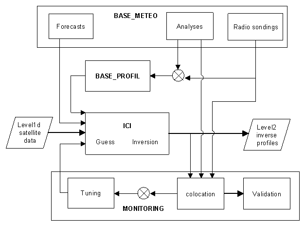
Diagram 1:Description of the ICI inversion processing system
Files from the ICI inversion software are sequential access binary files
with one record per situation, containing the level1 input data, environment
data, surface meteorological forecasts, the atmospheric profile used for
initializing the inversion as well as the retrieved profile. See detailed
description of format in the ICI software description [4].
The inversion system is made up of several modules corresponding to some main programs and unrelated scripts. These modules are run at different times of the day. The main modules are the following:
ICI: it is the heart of the software. Activated in real time after acquisition and just after pre-processing a new orbit, it reads the observation file in the level1d format, output of the AAPP preprocesses. It also reads the surface parameters forecasted by a numerical weather model, computes cleared radiance if necessary, initializes the inversion with a probable atmospheric profile, carries out the inversion and writes the inverted profile into the output file.
Four coding routines can be activated automatically according to the user?s requirements: ASCII files likely to be used by an occasional user, the AAPP level2 standard files, SATEM format files (to be assimilated in the monitoring of the numerical forecasting model) or files in the GRIB meteorological standard, a format used in particular for their display on the Météo-France Synergie graphic display units. ASCII files are described in [4] and the AAPP level2 files are described in [2] Vol.2. At the CMS, the ASCII, SATEM and GRIB files are presently being compiled.
BASE_METEO: this module creates a meteorological library containing radio soundings, analyses as well as forecasts on temperature and moisture in altitude and on the surface. Supplied by BDM and BDAP data, the library is meant to provide the meteorological data required for the ICI inversion (forecast), the BASE_INITIALE (analyses) and the MONITORING (radio soundings and analyses). This module is activated four times a day at the CMS by ?crontab? independently from real time processing of acquisitions.
BASE_PROFIL: this module creates a library containing temperature and moisture atmospheric profiles used for initializing the inversion with a vertical profile (guess) close to the retrieved one. The profiles of the library should be representative of the meteorological situation encountered. If it is not possible to construct such a data set, it is then necessary to consult a climatology library. Each profile is associated with up and down synthetic radiance as well as with the total satellite-surface transmittance. The module is run once a day at the CMS by crontab.
MONITORING : this module has a double purpose: first, to reset the inversion model in order to ensure a stable and durable quality for the retrieved profiles by readjusting the statistic coefficients of the software on a regular basis (tuning), and secondly to provide a regular quality follow-up (validation). For both actions co-located data files (co-location) are used. They contain satellite data, the retrieved profile, the radio-sounding and/or the closest analysis in time and space. The module is activated four times a day at the CMS, after acquiring meteorological observed data.
A more comprehensive scientific description of each module is given in section 6, and other details can be found in the software architecture, document [4].
Release 1 of ICI, operational since march 1996, used to process Noaa12 and Noaa14. It was replaced in September 1998 by a second release which processes TOVS and ATOVS (Noaa14 and Noaa15) simultaneously.
Research and development is still in progress so that the characteristics
of the new AMSU sounder are considered and that the accuracy of inversions
is improved. That is why the developments planned for release 3 are mentioned
in the description. This release should come out in the middle of 1999.
- Spectral absorption by the atmosphere
- transition of an atom electron from one energy level to another:
Due to the concentration and distribution of the atmospheric components, the atmosphere acts as a filter over radiation; some wave-lengths are largely reduced while others are freely go through the atmosphere. As a matter of fact, each component absorbs and transmits electromagnetic radiations at very precise frequencies and can be specified by a spectral signature indicating the wave-lengths absorbed by this component. The most important absorbing agents in the atmosphere are CO2, H2O, O2 and N2O, the main ones, for our observations, being CO2 for temperature profile retrieval and the H2O for moisture profile retrieval. Such emissions are due to 3 factors: